When Photography meets great Building, we get ART! (Irene Kung)
Sejima and Nishizawa Win 2010 Pritzker Prize (Arch Record)
The Earth Hour wasn’t as expected (MetroNews)
Salt Building merges old and new in Vancouver (Journal of Commerce)
The Zipline of Vancouver makes it to BBC (BBC)
Interesting showcase of international “walk” symbols found on traffic signals around the globe (1 Design per Day)
Underpass in Toronto Finds New Life As Park (Planetizen)
SDOT releases new bike map for Seattle! (Seattle DOT)
New high-speed rail network could trump air travel (Edmonton Journal)
How to get a crosswalk for your neighborhood in 6-ish weeks (GOOD)
A day in the life of New York City, in miniature (VIMEO)
Genius Loci: Brewery District
by Kate Howe, Urban Planner for VIA Architecture
 In the Pacific Northwest, Tacoma struggles somewhat from its brand as a post-industrial place. But, I and many, many others HEART Tacoma for its deeply layered and intense urban infrastructure; it holds a similarity for rust belt and east coast cities we keep hearing about, like revitalizing Pittsburgh (see the link for a New York Times article), Youngstown and Providence. Because these communities are still scarred by economic loss, they appreciate that without the ability to adapt, experiment and elevate the cultural attributes of their existing place, the free flow of unencumbered capital $ will do just that, keep on flowing right out of town.
While its situation is drastically different from a growing Pacific Northwest, I am particularly impressed by Youngstown OH, which is making a name for itself as one of the most experimental planning cities in the US, with its shrinking city concept. It is led by the country’s youngest mayor (elected at the tender age of 33). Now in his second term, his city is making headlines as one of the best places in the country to start a business.
Tacoma is hard at work at its own structural re-invention. Over the past year, they have adopted a new downtown strategic plan, a new downtown comprehensive plan, and development studies for some of its key neighborhoods.

For the Brewery District, a group of stakeholders, including the Hillside Development Council, the University of Washington (their new campus is just next door), the city, the arts community, business and land owners, recently came together to talk about what they would like to be. There is a lot of optimism surrounding the future of the District; in nearly every meeting, someone would mention wanting to be more like Granville Island, Vancouver. The Brewery District has decided on a Tacoma-driven, south sound, flavor – a diverse and activated place of production.


“Production” instead of “industry” underlies a progressive diversification of meaning. We are moving away from location-specific industry; and “production” suggests an evolution, signifying technological innovation and adaptation such as the need for robustness, resilience and environmental sustainability.

The actions suggested by the Brewery District groups and documented in a new Study due out soon includes:
This is an early peek at some of the ideas the VIA team produced as part of our exploration:


While its situation is drastically different from a growing Pacific Northwest, I am particularly impressed by Youngstown OH, which is making a name for itself as one of the most experimental planning cities in the US, with its shrinking city concept. It is led by the country’s youngest mayor (elected at the tender age of 33). Now in his second term, his city is making headlines as one of the best places in the country to start a business.
Tacoma is hard at work at its own structural re-invention. Over the past year, they have adopted a new downtown strategic plan, a new downtown comprehensive plan, and development studies for some of its key neighborhoods.

For the Brewery District, a group of stakeholders, including the Hillside Development Council, the University of Washington (their new campus is just next door), the city, the arts community, business and land owners, recently came together to talk about what they would like to be. There is a lot of optimism surrounding the future of the District; in nearly every meeting, someone would mention wanting to be more like Granville Island, Vancouver. The Brewery District has decided on a Tacoma-driven, south sound, flavor – a diverse and activated place of production.

Granville Island, Vancouver

“Production” instead of “industry” underlies a progressive diversification of meaning. We are moving away from location-specific industry; and “production” suggests an evolution, signifying technological innovation and adaptation such as the need for robustness, resilience and environmental sustainability.

The actions suggested by the Brewery District groups and documented in a new Study due out soon includes:
- Adaptive re-use of a former carriage house into a public market/incubator space;
- The introduction of a gathering place and bike/ped path on a decommissioned BNSF rail line;
- Potential for an art school, live-work lofts or more activated public use in the Nisqually Power Station (now owned by Tacoma’s most famous glass artist Chihuly);
- A new arts complex for a variety of performance managed by the School of the Arts just up the street;
- Reintroducing the original brick on Holgate Avenue to slow traffic and take back the public realm as a shared space.
This is an early peek at some of the ideas the VIA team produced as part of our exploration:


Free transit zones – are they worth it?
by Stephanie Doerksen, VIA Architecture Vancouver Office
At the beginning of 2010, two American cities made notable changes to their transit systems. Baltimore implemented the first of three entirely free bus routes called the Charm City Circulator, while Portland began charging bus fares in its well-known “Fareless Square” downtown.
 Those looking for trends in the transit world will certainly be confounded by these opposing moves. What do they indicate about the viability of free public transportation for inner cities?

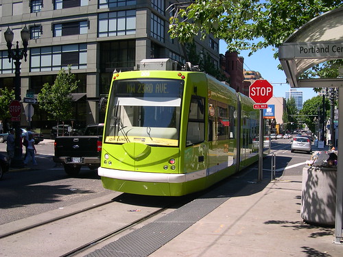
A large area of downtown Portland, commonly known as “Fareless Square” has been a free transit zone since 1975. It was initially implemented to combat air pollution and a lack of parking in the downtown core. Although the square has succeeded in attracting greater transit use, it has also been faulted for encouraging crime and annoyance on buses. This type of free transit zone also makes it slightly more difficult to collect fares when patrons board buses in the free zone and then continue travelling outside the zone.

Trimet (Portland’s regional traffic agency) reasons that 34 years ago when the square was implemented, bus service was the predominant form of public transit. With the recent expansion of the MAX light rail system, in conjunction with the streetcar, Trimet claims that 95% of trips within the square can be accommodated on these systems, which remain free within the zone (now referred to as the “Free Rail Zone”). They have also cited increased revenue from bus fares as an incentive for the move.
 While Portland is trying to capitalize on fares in order to expand service, Baltimore has implemented a tax on parking. The 16% parking tax, expected to generate about 5 million annually, will be used to fund The Charm City Circulator, a series of 3 free cross-town bus routes. The city is hoping that free transportation linking downtown and key sites around the city will provide some economic benefit by encouraging shopping and patronage of the city centre and entertainment districts. Not only will these lines be free, but they have dedicated lanes through congested areas of Baltimore, ensuring that service will be efficient and the planned 10 minute headways can be provided.

So what can we learn from these examples about the relative merits and drawbacks of free transit lines or zones for inner cities?
Firstly, increased transit ridership equals economic benefits. Or at least, the City of Baltimore is sufficiently convinced of this to implement a comprehensive and well-thought-out transit strategy, including a new tax to fund it.
Secondly, the fare (or lack thereof) is not the whole picture when it comes to encouraging transit use. True, paying a fare can be a psychological barrier, even if the fare is very affordable. I know I’ve opted to drive and put my $2 in a parking meter rather than use the same $2 for the bus. However, convenience and efficiency are real attractors to a mode of transportation and in order for a free transit area to be useful it also has to provide good service. As an aside I should add that this assertion is borne out by my experience of living in Calgary for 4 years, during which time I never once used the free light rail that traverses downtown (it was generally faster to walk!).
 The structure of the free transit system is also important, in order to reduce some of the potential drawbacks, such as difficulty in collection fares when travelling outside the zone. Baltimore avoided this problem by making the entire Circulator route free. This can be accomplished on a smaller scale by using a dedicated downtown bus or streetcar. When integrating with systems that use an honour system (generally combined with ticket checkers) like Vancouver’s Skytrain, the fare collection issue isn’t a problem.
Lastly, despite the fact that adding a free transit zone or line may increase ridership, it’s not going to pay for itself. Cities considering this option would be wise to look to the indirect benefits of free transit service –increased urban vitality, greater social equity, economic stimulus, decreased pollution and vehicle congestion- and then find a supplementary way to fund it.
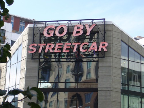
Image Credits: Portland Streetcar, GoByStreetcar, SaveFarelessSquare, Portland Bus, Baltimore1, Baltimore2
At the beginning of 2010, two American cities made notable changes to their transit systems. Baltimore implemented the first of three entirely free bus routes called the Charm City Circulator, while Portland began charging bus fares in its well-known “Fareless Square” downtown.


A large area of downtown Portland, commonly known as “Fareless Square” has been a free transit zone since 1975. It was initially implemented to combat air pollution and a lack of parking in the downtown core. Although the square has succeeded in attracting greater transit use, it has also been faulted for encouraging crime and annoyance on buses. This type of free transit zone also makes it slightly more difficult to collect fares when patrons board buses in the free zone and then continue travelling outside the zone.

Trimet (Portland’s regional traffic agency) reasons that 34 years ago when the square was implemented, bus service was the predominant form of public transit. With the recent expansion of the MAX light rail system, in conjunction with the streetcar, Trimet claims that 95% of trips within the square can be accommodated on these systems, which remain free within the zone (now referred to as the “Free Rail Zone”). They have also cited increased revenue from bus fares as an incentive for the move.


So what can we learn from these examples about the relative merits and drawbacks of free transit lines or zones for inner cities?
Firstly, increased transit ridership equals economic benefits. Or at least, the City of Baltimore is sufficiently convinced of this to implement a comprehensive and well-thought-out transit strategy, including a new tax to fund it.
Secondly, the fare (or lack thereof) is not the whole picture when it comes to encouraging transit use. True, paying a fare can be a psychological barrier, even if the fare is very affordable. I know I’ve opted to drive and put my $2 in a parking meter rather than use the same $2 for the bus. However, convenience and efficiency are real attractors to a mode of transportation and in order for a free transit area to be useful it also has to provide good service. As an aside I should add that this assertion is borne out by my experience of living in Calgary for 4 years, during which time I never once used the free light rail that traverses downtown (it was generally faster to walk!).

Lastly, despite the fact that adding a free transit zone or line may increase ridership, it’s not going to pay for itself. Cities considering this option would be wise to look to the indirect benefits of free transit service –increased urban vitality, greater social equity, economic stimulus, decreased pollution and vehicle congestion- and then find a supplementary way to fund it.
Image Credits: Portland Streetcar, GoByStreetcar, SaveFarelessSquare, Portland Bus, Baltimore1, Baltimore2
Monday News Roundup
Every Monday, we post links to articles and blogs that you may have missed from last week. Enjoy!
World’s High-Speed Train Makers Set Sights on U.S. (NY Times)
"Central Japan Railway and China South Locomotive & Rolling Stock are competing for the $8 billion that President Barack Obama has granted for 13 high-speed corridors across the United States, including a line between Tampa and Orlando in Florida that may include a station at the Walt Disney resort near Orlando."
Letter from Baltimore: The Humanitarian-Design Debate (Metropolis Mag)
"Nothing—not even well-intentioned design—is above reproach. The confluence of organizations and individuals working to bring design practice to those who might not normally get it seems to have hit a critical mass, and with it comes the inevitable backlash."
White House Releases Climate Change Adaptation Report (NRDC)
President Obama’s Interagency Climate Change Adaptation Task Force releases Climate Change Adaptation Interim Report.
Climate Change Problems hit Native Americans (Carbon Based Climate Change Adaptation)
Studies show that mountain snowpack in Montana is melting an average of three weeks earlier in the spring, threatening native fish and putting pressure on agricultural use of water. On the Flathead reservation hydropower and electricity generation is threatened by low water levels, potentially hurting business.
We Will Take Transit if it Meets our Needs (NRDC)
Discusses the use of transit from the perspective of availability and cost rather than a subjective opinion that touts environmental contentiousness.
Midwest gets a jump on high-speed rail (Christian Science Monitor)
"Illinois Gov. Pat Quinn, center, announced on Jan. 29, 2010, in Chicago's Union Station that Illinois will receive more than $1 billion of stimulus money for the development of high-speed rail in the state. In preparation, Union Station itself will be renovated."
Africans 'take blame for climate change' (BBC News)
"Many Africans blame themselves for climate change even though fossil fuel emissions there are less than 4% of the global total, a new survey suggests."
Best of Inhabitat: 6 Super-Cool Floating Homes and Habitats (Inhabitat)
"While we're working on actually mitigating global warming, architects, designers and visionaries are one step ahead, imagining homes, buildings and entire cities situated above or even beneath the surface of the world's oceans. Check out our favorites that we've seen 'floating' around."
The Non-Legacy of the 2010 Expo (Next American City)
"Ever since Prince Albert invited the world to London’s Hyde Park in 1851 and dazzled them with the Crystal Palace, grand expositions have been seen as one of the premiere forums for daring, inventive architecture. The temporary nature of these events and the spirit of (ostensibly) friendly competition that fuels them creates an environment in which architects are encouraged to experiment. In more recent decades, expos have, at least in the United States, taken a back seat to Olympic ceremonies when it comes to international competition; and, like expos, these events are seen as plum opportunities to show off daring, high-profile designs."
Top 10 things you probably didn't know about VIA
In honor of our 100th post (!), we asked our staff to submit things that VIA has done or accomplished in the last 25 years. Out of a list of 100 entries (because you probably wouldn't stick around long enough to read all 100), here are our top 10:
1 We designed one private residence that required higher levels of security than our work for the US Department of Homeland Security
2 VIA is the first Architectural firm known to incorporate the now popular “Dress as your favorite Revit Command Day” into its annual holiday schedule
3 Alan Hart (founding principal) is really a Blackberry in a man’s body
4 Translink, in an effort to show their appreciation for all VIA does for them, has both routes of the ever popular #17 bus say our name every time the doors open! "UBC. VIA. Downtown." "Oak. VIA. Downtown."
10 We like to go to the end and come back
5 Everyone at our firm knows that inside every car is at least one pedestrian
6 Amongst our staff, we have an artist, a jazz musician, a few photographers, a boat enthusiast, a farmer, parents, a hip hop artist, a few flâneurs, a mushroom forager, a poet, bloggers, the wife of an olympian (archery), a choralist, community activists, a wine maker, runners, bicyclists, sailors, and some things that just can’t be written
7 Is it “vee-yah” or is it “vye-uh”
8 Our firm has so many competitions between the offices throughout the year, we compromise for our annual summer picnic by meeting at Peace Arch Park (right at the border) -- no border traffic, and no risk of deportation
9 We now have sweatshirts, t-shirts, sweatpants, coffee cups, water bottles, umbrellas, backpacks, blankets, laptop bags, hats, vests, jackets, and pencils, all with our "blue V" logo. A few of our staff have been around long enough to be completely decked out in VIA apparel

Paralympics Opening Ceremonies: One Inspires Many

Having recently had the pleasure of watching the Paralympic opening ceremonies, I can say that “one inspires many” is a very appropriate theme. While the Olympics appear to be about pushing yourself with “Faster, Higher, Stronger” as their motto and a creed which encourages the fight and the struggle; the Paralympics are about inspiration and spirit. With a motto like “spirit in motion” and this years inspiring ceremony, I think they spread their message well.

Not only were the performances inspiring, they were also amazing to watch. I think everyone’s jaw dropped when Montreal born Luca Patuelli’s used his crutches to propel himself upwards during his break dancing number. Patuelli, who goes by lazylegz, has needed crutches since the age of three but his outlook is, without a doubt, inspirational. During his performances he uses his crutches as an extension of his arms, he says "yeah, I need them, but what people might see as a disadvantage, I use as an advantage."
Following Luca were some presentations that were a little more emotionally driven including those about Rick Hansen’s man in motion tour and Terry Fox’s marathon of hope. These two BC athletes have truly embodied “where there’s a will there’s a way.” Terry Fox had a vision to raise $1 for each of the 24 Million Canadians for cancer research, a vision which he well surpassed having raised over $400 million to date. Rick Hansen had a similar vision, to raise money for spinal cord research after he himself was forced into a wheelchair at the age of 15. After raising $26 million, he too was hailed as a national hero.

Terry Fox drew his motivation from the need to increase funding for cancer research after he learned that his chances of surviving were 50% while only two years earlier they would have been 15%. While fundraising to begin his tour he wrote “I am not a dreamer, and I am not saying that this will initiate any kind of definitive answer or cure to cancer. But I believe in miracles. I have to.” Fox ran 26 miles, which is a full marathon, each day for 143 days. Despite the pain caused by his prosthetic leg and from this exhaustive feat, he continued and ran without taking a day off covering 5,300 kilometres.
His marathon of hope was cut short when his cancer returned, this time spreading to his lungs. Miracle or dreamer, Terry Fox is seen as one of the most influential people in Canadian history. While referring to Fox, Pierre Trudeau stated that "It occurs very rarely in the life of a nation that the courageous spirit of one person unites all people in the celebration of his life and in the mourning of his death....We do not think of him as one who was defeated by misfortune but as one who inspired us with the example of the triumph of the human spirit over adversity"
The end of Terry’s presentation at the opening ceremonies was marked by his parents entering with the Olympic flame which had come from a 24 hour torch relay in Vancouver’s downtown core. The flame was passed to 15-year-old Zach Beaumont who lit the cauldron. Beaumont had his leg amputated as a baby and would like snowboarding to be added to the Paralympics so he too can compete. It was a tribute to the future athletes that will compete at the games.

The Paralympics consist of athletes all of whom have overcome significant barriers and challenges. Each one of them has a touching story and the drive and passion to prove to us the profound nature of the human spirit. Although the Paralympic ceremonies were not quite as grandiose as the Olympic ceremonies, they truly sent us home with a feeling of hope and achievement, indeed one inspired many.

Mapping [City DNA]

Question:
What makes urban design flourish in some cities but remain backwards in others?
My answer:
Successful cities already have their [City DNA] mapped out.
The Idea:
This is my attempt to explain why urban design remains unsuccessful in many cities around the world, while in others it is able to flourish and grow. In the process, I will also attempt to identify the element of urban design that is often missing in many of these failing cities.
Successful urban design tasks should start with a basic understanding of a physical location’s various dimensions; such as history, culture, environment, and architecture as well as the behaviors of its inhabitants. I’m calling it [City DNA], where specific elements of a city are mapped out, researched, published, taught, understood, implemented and challenged in order for that specific city to grow in its proper context.
I’ll start my argument by highlighting two essential points from two important articles written specifically about the Dubai experiment. These points will demonstrate how important it is to understand a city’s [City DNA] if we want it to develop into a healthy urban area with a promising and sustainable future
Article 1:
The first article I’m linking to here is written by Michael Sorkin for the August 2009 issue of Architectural Record, titled: Connect the dots: Dubai, labor, urbanism, sustainability, and the education of architects 1
Sorkin states:
“This is an environment designed by the world’s best and brightest, and for many, a paradigm of global inevitableness.”
Note 1: Regardless of who is hired to design and build any project in a city, if the designer, being an architect or a planner, does not understand the [City DNA] of that specific city, the results will be unsuccessful.
Article 2:
The second article is written by Blair Kamin for the Chicago Tribune on January 08, 2010, titled: In Dubai, you can't get there from here; architectural feats undercut by shoddy urban planning 2
Kamin states:
“A tour of this once-booming Persian Gulf city-state, which has shifted into low development gear from hyper-drive, reveals a disturbing disconnect between its architectural spectacle and its short-sighted development practices.”
Note 2: Regardless how spectacular a city’s architectural forms are, if the designer, being architect or planner, doesn’t understand the [City DNA] of that specific city, the results will be unsuccessful
Prototype:
While I was studying in Japan, I met an exchange student from Columbia University who came to our laboratory to work on her research project. She was developing a theoretical comparison between Western cities and Japanese cities.
Through her studies, she came up with an amazing compilation of the differences between the two types of cities, but for me, her research was more than that-- it was the base of my idea to treat our cities in the same manner as we treat any creature on the planet.
To cure or prevent a disease, we need to know the genetic elements of the creature needing treatment so that we can better understand how its body works. Cities are no different than any creature. Some cities may grow, some get polluted, and some get totally destroyed.
To fix and prevent problems or to revive a failing city we must have their genetic map that consists of not only the basic physical elements but also the philosophical elements, which I have termed as [City DNA].
I’m going to use my colleague’s model as a prototype of how the [City DNA] element applies to our cities:
The Western City
(Kevin Lynch):
- The imaginable city,
- Encourage pride through distinction,
- Linear relationship,
- Understandable when put in map plan
- The city skeletal structure that consist of (Path, Edge, District, Node and Landmark,)
Lines of vision and movement; channels and speeds movement
Edge:
Boundary or break in continuity
District:
Area of a city with common identifying characteristics
Node:
Convergence of paths or concentration of paths or concentration of activities
Landmark:
Visual reference points within a city often acts to reinforce the node
The Japanese City
(Gunter Nitschke and Yoshinobu Ashihara):
- The experiential city
- Fosters harmony through uniformity, fragmented image makes the individual feel part of the larger whole
- Special relationship
- Ambiguous in map and plan
- Molecular structure: additive, clustered, non-hierarchical (Link, En, Dividuum, Ma, Natural context)
Network of access routes; disperses and slows movement
縁 (en):
Transactional space; simultaneously the connection and / or separation between spaces
Dividuum (Dividual):
Part split from and belonging to the whole
間 (ma):
Place or space; understood as the place for tea ceremony or formal space
Natural context:
Topography and surrounding natural elements
What if?
What if every city in the world succeeded in mapping out its [City DNA] in a way similar to the Lynch, Nitchke and Ashihara theories? And in doing so, what would our cities and urban centers look like?
Would it look completely and perfectly transformed?
No! Paris, London, Tokyo, New York, Damascus, and Vancouver are not going to look much different than its physical characters of today. But as long as our ideas continue to be centered on [City DNA], any future developments in any city in the world will be built smarter, greener, more adaptive to its unique community; and, above all, they will become better integrated and harmonized with the city, its fabric, its culture, its environment and its residents.
This is the new generation of cities we need today and the path that leads to creating accurate [City DNA] maps starts with serious collaborations between universities, research centers, urban consultants, architects, philosophers, historians as well as municipalities and local communities. Discussion and not disagreement is what our cities are asking us to do and we are obliged to do exactly that.
Demystifying the Location Efficient Mortgage
by Amanda Bryan, Intern Architect at VIA Architecture
Like many other young people just setting down roots and trying to grasp the finer details of what it means to be in the ‘real world’ (a.k.a. no longer a student), I found myself feeling rather ignorant when people started bringing up topics like mortgages and prequalified buyers – let alone ‘location efficient mortgages.’ However, I am apparently not the only one who is at a loss on this topic since there seems to be a general lack of knowledge on the subject. So what exactly is a Location Efficient Mortgage and why is it worth knowing about?
What is a ‘Location Efficient Mortgage’ and why does it exist?
A Location Efficient Mortgage (LEM) is a type of mortgage created for homebuyers to incentivize purchases made in urban areas that accommodate walking to nearby stores, schools, parks, and public transit. At the consumer level, the LEM provides more opportunities for low and middle income homebuyers, who would ordinarily be forced to live in less expensive fringe areas, to buy into transit and amenity rich areas. At the broader national level, these loans satisfy four overarching goals:
In many ways an LEM is similar to a standard Federal Housing Administration (FHA) loan because it specifically targets borrowers that struggle to amass a traditional 20% down payment by allowing a reduced down payment of only 3%. Like FHA loans, LEMs also allow borrowers to ‘stretch’ their Housing-to-Income and Debt-to-Income ratios, traditionally set at 28% and 35%, to an increased rate of 35% and 45% respectively.
However, an LEM is different from an FHA loan in a couple of ways. First, an LEM is predicated upon a homebuyer’s selection of a neighborhood which allows them to reduce their vehicle driving needs by incorporating a diverse set of amenities such as grocery stores, parks, and transit within walking distance. Second, a mathematically derived ranking system for urban neighborhoods coupled with a buyer’s borrowing power is used to determine their Location Efficient Value (LEV). The LEV can then be calculated into a buyer’s gross income, thereby increasing their prequalification amount. To see how this process works in real time go to: http://www.locationefficiency.com
What research prompted the creation of LEMs?
In a 1989 study by Peter Newman and Jeffery Kenworth, it was found that gasoline consumption in U.S. cities far exceeded that of 32 other major international cities. For example, Americans consumed nearly twice as much gasoline per capita as Australians, four times as much as compact European cities, and ten times as much as westernized Asian cities.[1]

Another way to understand how auto ownership figures into the Location Efficient Mortgage is to understand the financial impacts due to foreclosures. The NRDC performed the “Location Efficiency and Mortgage Default” study which pulled highly detailed performance data on 40,000 mortgages in Chicago, Jacksonville, and San Francisco. After accounting for factors such as income, age of mortgage, and population growth, the study shows that the probability of mortgage foreclosure decreases in neighborhoods where less car reliance is possible.[2]

What does this all mean for the average homebuyer and our urban condition?
While the LEM may not be the absolute answer for driving consumers toward purchasing in urban areas (described more in depth here), it does have the potential for opening up a more efficient and progressive housing market for the younger generations like myself. If the LEM can build up enough critical mass, attracting homebuyers to areas of smart growth augmented by great transit connectivity, there is the potential for our cities to regain the social amenities critical for livability. As for those of us wishing we could afford a home close to work, play, and everything else in-between, there might be a small glimmer of hope.
[1] http://docs.nrdc.org/air/files/air_06031001a.pdf
[2] http://www.nrdc.org/energy/files/LocationEfficiency4pgr.pdf
Like many other young people just setting down roots and trying to grasp the finer details of what it means to be in the ‘real world’ (a.k.a. no longer a student), I found myself feeling rather ignorant when people started bringing up topics like mortgages and prequalified buyers – let alone ‘location efficient mortgages.’ However, I am apparently not the only one who is at a loss on this topic since there seems to be a general lack of knowledge on the subject. So what exactly is a Location Efficient Mortgage and why is it worth knowing about?
What is a ‘Location Efficient Mortgage’ and why does it exist?
A Location Efficient Mortgage (LEM) is a type of mortgage created for homebuyers to incentivize purchases made in urban areas that accommodate walking to nearby stores, schools, parks, and public transit. At the consumer level, the LEM provides more opportunities for low and middle income homebuyers, who would ordinarily be forced to live in less expensive fringe areas, to buy into transit and amenity rich areas. At the broader national level, these loans satisfy four overarching goals:
- Boost public transit ridership
- Reduce energy consumption
- Improve local and regional air quality
- Encourage development of more efficiently designed communities
In many ways an LEM is similar to a standard Federal Housing Administration (FHA) loan because it specifically targets borrowers that struggle to amass a traditional 20% down payment by allowing a reduced down payment of only 3%. Like FHA loans, LEMs also allow borrowers to ‘stretch’ their Housing-to-Income and Debt-to-Income ratios, traditionally set at 28% and 35%, to an increased rate of 35% and 45% respectively.
However, an LEM is different from an FHA loan in a couple of ways. First, an LEM is predicated upon a homebuyer’s selection of a neighborhood which allows them to reduce their vehicle driving needs by incorporating a diverse set of amenities such as grocery stores, parks, and transit within walking distance. Second, a mathematically derived ranking system for urban neighborhoods coupled with a buyer’s borrowing power is used to determine their Location Efficient Value (LEV). The LEV can then be calculated into a buyer’s gross income, thereby increasing their prequalification amount. To see how this process works in real time go to: http://www.locationefficiency.com
What research prompted the creation of LEMs?
In a 1989 study by Peter Newman and Jeffery Kenworth, it was found that gasoline consumption in U.S. cities far exceeded that of 32 other major international cities. For example, Americans consumed nearly twice as much gasoline per capita as Australians, four times as much as compact European cities, and ten times as much as westernized Asian cities.[1]

A comparison of American’s gasoline consumption in relation to three other westernized cultures.
Another way to understand how auto ownership figures into the Location Efficient Mortgage is to understand the financial impacts due to foreclosures. The NRDC performed the “Location Efficiency and Mortgage Default” study which pulled highly detailed performance data on 40,000 mortgages in Chicago, Jacksonville, and San Francisco. After accounting for factors such as income, age of mortgage, and population growth, the study shows that the probability of mortgage foreclosure decreases in neighborhoods where less car reliance is possible.[2]
Comparative analysis showing the relationship between transportation costs and location efficiency (link)
What does this all mean for the average homebuyer and our urban condition?
While the LEM may not be the absolute answer for driving consumers toward purchasing in urban areas (described more in depth here), it does have the potential for opening up a more efficient and progressive housing market for the younger generations like myself. If the LEM can build up enough critical mass, attracting homebuyers to areas of smart growth augmented by great transit connectivity, there is the potential for our cities to regain the social amenities critical for livability. As for those of us wishing we could afford a home close to work, play, and everything else in-between, there might be a small glimmer of hope.
[1] http://docs.nrdc.org/air/files/air_06031001a.pdf
[2] http://www.nrdc.org/energy/files/LocationEfficiency4pgr.pdf
Monday News Roundup
#1 Tweet from last week: Granville Street during the Olympics vs. Granville street today
PREFAB FRIDAY: Beautiful Green Roofed Affordable Housing In the UK (Inhabitat)
“Affordable housing meets stylish design, renewable energy, green roofs, energy efficiency and prefabricated construction in this fantastic housing project in the London Borough of Hillingdon.”
Biking in Portland to become as mundane as housework (Momentum)
Lost in Penn Station: Wayfinding in huge transit hubs (Slate)
Why are the signs at the nation's busiest train hub so confusing?
Pedestrian Survival Techniques (Discovering Urbanism)
Interesting post about trying to be a pedestrian in the middle of a city.
Samuel Cochran of SMIT (Design Glut)
SMIT’s products are beautiful, sophisticated panels for harnessing renewable energy. Their work is already in MoMA’s permanent collection.
The Future of Cities in the Internet Era (Next American City)
Ever since humans began to organize themselves in cities, people have been wondering what the cities of the future would look like. Many urban advocates and policy makers are now recognizing the extraordinary potential to use these mobile phones, personal computers + the internet to engage citizens and ultimately improve the way cities work.
Practicing cautionary placemaking: urbanism and the Venetian Ghetto (my urbanist)
Provocative post placing new urbanism and density in historic context. Where does this new one - of transit oriented communities' fit?
San Francisco Solar Map
A map of solar activity throughout San Francisco
Entire cities recreated from Flickr photos (New Scientist)
3D computer models of beautiful cities produced in a day using crowd-sourced snaps
The Work of Art in the Age of Digital Pre-production (Quiet Babylon)
Cameron Moll has created a poster that depicts the Coliseum using type. The Colosseo is a gloriously hybrid entity, digitally produced but mechanically reproduced. The prints are these beautiful objects, but the Colosseo is also data.
A local lesson in transit orientation (@Kaid_at_NRDC)
"Several weeks ago, I ran a post making the case that transit-oriented development requires more than just transit and development. As the phrase implies, it also requires orientation: the development must relate to and be convenient to the transit. There is also a body of practice and research on the closely linked subject of walkable neighborhoods, which require more than just sidewalks and places you might want to go within theoretical walking distance."
Vancouver 2010 Winter Olympics from a Foreign Perspective – Part 2: Post Olympics
by Jennifer Kennefick, VIA Architecture
Link to Part 1: Pre-Olympics
One Olympics down, one to go! And didn’t the first installment go well!! The hosts could not have asked for a better result, with Canada winning 26 medals and 14 of them gold. And to top it all off, on the last day, a fairytale hockey ending, with Canada beating the USA in extra time and Sidney Crosby scoring the winning goal. It was like a scene from a Mighty Ducks film!
So, what happened to all the worries and concerns regarding the lack of snow and the ‘outrageous’ amounts of people?
Snow: No real problems; Whistler had plenty and Cypress had prepared enough in advance to deal with the precipitation shortages!
Crowds: Amazing! So many people, in such a great mood and dealt with so well.
The Olympics really tested the city, tested it to see how it would deal with such an influx of people and exposure. It was tested infrastructurally, socially, culturally, spiritually and I feel that it passed on every level.
A major worry people had prior to the start of the Games was problems and crowds on public transport, which in my experience wasn’t too bad at all. For me, the main problem was the crowds for entertainment events! The queues to get into many of the events and various international houses were crazy! I guess when you think about it, it wasn’t really a bad thing after all! Better to have too many people than not enough!

And like anyone else who said “Sure the Olympics are only here once!” I did my fair share of queuing for various events, and most of what I queued for was well worth it in the end. As a little aside, I have to mention that there was one perk of being ‘foreign’ during the Olympics. I got to skip the queue and forego the cover charge to The Irish House. Sweet!
I was very impressed with the effort around the city by vendors and shop owners, especially here in Yaletown. The streets were lined with stalls, food vendors, exhibits etc. There was really a great buzz around, with people from all over the world proudly wearing their country colours and checking out what the area had to offer.

There is nothing like an international sporting event to bring people and countries together. Everyone wants to see their country do well. The friendly banter both within and across border divides makes for strengthened relationships and for fun! Working in a fairly multi-cultural office, made for lots of banter and for running in and out of the boardroom to watch our various countries competing via live online stream on our big screen!
For me, the last 2 weeks have really reinforced the importance of sport and sporting events in society. They also highlighted that facilities for both playing and watching sports are really important to the success of cities. This is true not only at the scale of an event like the Winter Olympics but also at the scale of the 7 a-side inter-office soccer leagues and friends who go to their local bar to watch the ‘game’!
 The Paralympics start today -- I guess it is inevitable that it won’t receive as much attention and press as the main Olympics, and it is not surprising either that most of the tents and country houses are not staying for its duration. But I for one am excited because it means that I can get my hands on tickets and it also means that the Olympic fun can continue for a little while longer, though perhaps maybe not on such an intense level!
Link to Part 1: Pre-Olympics
One Olympics down, one to go! And didn’t the first installment go well!! The hosts could not have asked for a better result, with Canada winning 26 medals and 14 of them gold. And to top it all off, on the last day, a fairytale hockey ending, with Canada beating the USA in extra time and Sidney Crosby scoring the winning goal. It was like a scene from a Mighty Ducks film!
So, what happened to all the worries and concerns regarding the lack of snow and the ‘outrageous’ amounts of people?
Snow: No real problems; Whistler had plenty and Cypress had prepared enough in advance to deal with the precipitation shortages!
Crowds: Amazing! So many people, in such a great mood and dealt with so well.
The Olympics really tested the city, tested it to see how it would deal with such an influx of people and exposure. It was tested infrastructurally, socially, culturally, spiritually and I feel that it passed on every level.
A major worry people had prior to the start of the Games was problems and crowds on public transport, which in my experience wasn’t too bad at all. For me, the main problem was the crowds for entertainment events! The queues to get into many of the events and various international houses were crazy! I guess when you think about it, it wasn’t really a bad thing after all! Better to have too many people than not enough!

And like anyone else who said “Sure the Olympics are only here once!” I did my fair share of queuing for various events, and most of what I queued for was well worth it in the end. As a little aside, I have to mention that there was one perk of being ‘foreign’ during the Olympics. I got to skip the queue and forego the cover charge to The Irish House. Sweet!
I was very impressed with the effort around the city by vendors and shop owners, especially here in Yaletown. The streets were lined with stalls, food vendors, exhibits etc. There was really a great buzz around, with people from all over the world proudly wearing their country colours and checking out what the area had to offer.

There is nothing like an international sporting event to bring people and countries together. Everyone wants to see their country do well. The friendly banter both within and across border divides makes for strengthened relationships and for fun! Working in a fairly multi-cultural office, made for lots of banter and for running in and out of the boardroom to watch our various countries competing via live online stream on our big screen!
For me, the last 2 weeks have really reinforced the importance of sport and sporting events in society. They also highlighted that facilities for both playing and watching sports are really important to the success of cities. This is true not only at the scale of an event like the Winter Olympics but also at the scale of the 7 a-side inter-office soccer leagues and friends who go to their local bar to watch the ‘game’!

The Great Vancouver Transit Experiment
by Lydia Heard, Urban Planner for VIA Architecture
Part 3 of A Citywalkers Take on Vancouver: Walking the Livable City looks at transit and transportation. Although a citywalker’s favorite mode of transportation is eponymous, transit greatly increases the reach of our feet, so to speak.
Walking the Livable City, Part 1
Walking the Livable City, Part 2
Vancouver made great strides in transit improvements even before the Olympics. What did they do in order to move a few hundred-thousand extra people around the city? Getting there to find out is a worthwhile journey in itself.
 From Train to Train
This was my first time taking the train, Amtrak Cascades, to Vancouver. We’ve been talking recently, in our Seattle and Vancouver blogger meetups, about how we’re part of one larger region (sometimes called Cascadia), and how we might start more dialogues about what that means. Taking the train through the region is a good reminder.
We travel in tunnels under cities and under wooded cliffs; through industrial yards and backyards; past cattle pastures, and fallow fields with grazing flocks of swans; by greenhouses, grain elevators and lumberyards; sloughs, ship channels and estuaries; and to the west, directly against the tracks for much of the way, that body of water that the two countries have agreed to call the Salish Sea, acknowledging Puget Sound and the Straits of Georgia as one great system of shared resource, beauty, and hazards. From the train you can see people walking on narrow shingle, flocks of bufflehead bobbing, bald eagles fishing, and the occasional seal, sea lion or whale. The San Juan Islands come to view, in between fern covered cuts and rocky cliffs topped with windswept conifers.

At every stop people are waiting for the train – a couple or a few at Edmonds or Stanwood, a fair group at Mount Vernon and Everett, a big crowd at Bellingham. The track is within view of I-5 from time to time; there is no envy here for the motorists on that dreadfully familiar drive. Here on the train, we are working by handheld or laptop, sleeping, going to the dining car, walking about the train, watching the scenery, reading, taking in the movie – wonderfully free from the monotony of hands on the wheel, eyes on the road.
Going into Canada, we cross the border without stopping, only a walkthrough to check passports and declaration forms. This is a different experience from crossing the border by car, where the wait times can be hard to predict and can be hours long in summer. According to DOT, the crossing times were surprisingly short during the Olympics, with 200,000 cars going north to Canada and 268,000 coming south (supposedly the extra were people who went north before the count started).
We pass the first Canadian town, White Rock, residences terracing up the hillside and every one with a view. The train engineer, our tour guide, informs us that it “takes a lot of dollars” to live there. He announces the Fraser River, and out the window is the beautiful Skybridge with the Skytrains crossing over, passing each other out there on the bridge. This is the longest cable-supported transit bridge in the world, and gorgeous. What does it take to build this sort of infrastructure, and these complete transit networks? I can only guess that, if a governing body has managed to avoid the commitment to building ever more highways, then there are more funds for transit than we seem to find here in the States.

My ardor for Canadian transit cools somewhat when the train arrives at Pacific Central Station. The platform is stingy and open to the rain; we wait in line outside of the small customs area. It’s still a much better experience than flying. Exiting the station dragging heavy bags, the forecourt is annoyingly free of any helpful wayfinding signage to the Main Street Skytrain station.
Even more annoying is the distance to the elevator, which is across a major street, and is hidden away without any hint of how to find it. This station was built in a short timeframe as a terminus platform for the Expo line of 1986. Plans have been made (by VIA for Translink) for a new station and are awaiting funding.

Once aboard the Skytrain all annoyance fades away. I forget my street, go a stop too far and head to another platform for a train back the other direction – I hope, but am not sure. I must look lost (as I often do) and a helpful soul asks if I’m heading for the airport, with my bags, obviously proud of the new Canada Line that goes there. I ask if this train goes back to Granville and get the affirmative. From now on it’s obvious, everywhere, all the time, that this is Vancouver, the Host City to the 2010 Olympics. It’s a constant invitation: Welcome World.
Invitation to Transit
A bus goes by, one of many, alternately flashing the route number and the message “WELCOME WORLD”. The buses are full, especially late at night when (a few) celebrants start going home. One night after watching the fireworks from the False Creek seawall, I walk west until the crowds have thinned, and find a tapas place on Howe. Everything is quiet except for the bus stop, where dozens of people are waiting for a bus.

Transportation demands during the Olympics were expected to be 30% greater than average; this was compounded by the various street closures and reduced capacity due to security at venues and to make pedestrian celebration streets. The various governing bodies and agencies involved with the Olympics developed a Host City Transportation Plan to meet the various goals and keep the city moving. One-hundred eighty additional buses were brought in, times extended and more frequent trips provided.

A key factor for bus efficiency was reducing other vehicle trips by 30%. Olympic lanes were designated on some streets for transit (and official Olympic vehicle) priority. Other streets were designated no stopping (no parking) except for buses. Residents were encouraged to plan transit, bike or walking trips rather than driving downtown.

This is my first visit since the Canada Line opened last August (ahead of schedule). It was carrying 90,000 riders a day even before the Olympics. I like to walk but am glad to take the train when time is short or my feet are sore. It’s very crowded; we joke back at the office that it’s like the Japanese trains, and they need the push shields that compress people into the cars so the doors can close. I get caught in the door, once.


That was on a weekday. One of my Seattle coworkers went on a sunny weekend and reported that there were long queues and waits to get on the train at all, so she just walked everywhere. During my weekday not-so-sunny visit the queue barriers are empty and unused and there was no waiting, just onboard crowding. The Canada Line was not considered part of the Olympic expenditures, as it is a permanent new system. I overheard one couple leaving the Yaletown-Roundhouse station talking about the Olympics features, then end the conversation with “…and this we get to keep”.

GO CANADA GO…by Streetcar

The Olympic Line is a demonstration streetcar which runs, until March 21, between Granville Island and the Canada Line Olympic Village station by Cambie. The track of the existing historic line was upgraded, with noise reducing welded rails, to run a modern Flexity streetcar on loan from Bombardier. They had 300,000 riders over 30 days. If funding can be found to purchase two or three cars, the line could become permanent and even be expanded into a network.

Our conductor and guide confessed to being old enough to have ridden the last of the streetcars that used to go to Stanley Park, and hoped to be around to see the network restored. The new streetcar lines in Toronto are to use Bombardier cars that will be manufactured there; that could be the source for any new Vancouver streetcars.
Cyclists Get a Full Plate

Good hosts not only send invitations; they offer their guest more than they can eat. Generous invitations increase the likelihood of greater acceptance, sooner or later. Vancouver was prepared for tremendous numbers of cyclists, just in case. Bike Valet stations were set up near Olympic venues to encourage cycling. There was already a good network of bike lanes on the streets, Cambie Bridge, and along trails and seawalls. New lanes were added in Gastown, DTES and Chinatown. Even before the Olympics barriers were set up on the Burrard Bridge to create bike lanes in both directions.


With access and infrastructure for cyclists as a high priority, people wondered why the Friday Critical Mass cyclist protest event was still held during the Olympics. The organizers said the Olympics weren’t a target; it’s just the usual reminder that cyclists have a right to the road, and a fun social event besides.

Transit Buffet: Better Than A-La-Carte
In the end, Vancouver didn’t come to a standstill during the Olympics. This was in part because many modes were available and somewhat integrated; not just one system but a combination of several. Heavy rail, light rail, streetcar, bus, increased bike and pedestrian options were provided, and still allowed for necessary vehicular traffic on the streets.

Many transit options provide flexible access to transit for more people. Some aspects were temporary. Just for the Olympics the transit agencies added 48 additional Skytrains and a third Seabus to North Vancouver, which along with the West Coast Express had extended times and increased runs. Transit systems carried about 1.6 million people per day, or twice the usual number, during the Olympics.

As a well planned experiment, it was so successful that some temporary measures may eventually become permanent, such as the streetcar. Because vehicular street traffic was successfully reduced, there is a renewed call for taking down the Georgia and Dunsmuir viaducts, those precursors to the downtown freeways that never happened, thanks to neighborhood activism – after the viaducts construction took out part of Strathcona (and are still inhibiting east end development). Largely because those freeways never happened, the city has enviable and extensive transit systems – but the calls for car freedoms are still there.
 There are claims that, in order to reach a 30% traffic reduction, Vancouver residents and people who work downtown were encouraged to take their vacations during the Olympics, and that the reduction shouldn’t be considered permanent. This was part of the debate over bike lanes on Burrard Bridge before the Olympics; the debate over the fate of the viaducts is continuing after.

Pedestrians Rule at the World’s Biggest Party
Pedestrians, or people walking, are the lifeblood of any great, livable city. The transportation plan designated pedestrian “celebration” streets on sections of Granville, Robson, Mainland and Beatty streets. These “streets for people” were very well used, and were indeed the life of the party. This topic deserves its own post.
Next: Public Spaces, People Places. Celebrations of people in the street and beyond.
Image Credit: Welcome World, Train, White Rock
Part 3 of A Citywalkers Take on Vancouver: Walking the Livable City looks at transit and transportation. Although a citywalker’s favorite mode of transportation is eponymous, transit greatly increases the reach of our feet, so to speak.
Walking the Livable City, Part 1
Walking the Livable City, Part 2
Vancouver made great strides in transit improvements even before the Olympics. What did they do in order to move a few hundred-thousand extra people around the city? Getting there to find out is a worthwhile journey in itself.

This was my first time taking the train, Amtrak Cascades, to Vancouver. We’ve been talking recently, in our Seattle and Vancouver blogger meetups, about how we’re part of one larger region (sometimes called Cascadia), and how we might start more dialogues about what that means. Taking the train through the region is a good reminder.
We travel in tunnels under cities and under wooded cliffs; through industrial yards and backyards; past cattle pastures, and fallow fields with grazing flocks of swans; by greenhouses, grain elevators and lumberyards; sloughs, ship channels and estuaries; and to the west, directly against the tracks for much of the way, that body of water that the two countries have agreed to call the Salish Sea, acknowledging Puget Sound and the Straits of Georgia as one great system of shared resource, beauty, and hazards. From the train you can see people walking on narrow shingle, flocks of bufflehead bobbing, bald eagles fishing, and the occasional seal, sea lion or whale. The San Juan Islands come to view, in between fern covered cuts and rocky cliffs topped with windswept conifers.

At every stop people are waiting for the train – a couple or a few at Edmonds or Stanwood, a fair group at Mount Vernon and Everett, a big crowd at Bellingham. The track is within view of I-5 from time to time; there is no envy here for the motorists on that dreadfully familiar drive. Here on the train, we are working by handheld or laptop, sleeping, going to the dining car, walking about the train, watching the scenery, reading, taking in the movie – wonderfully free from the monotony of hands on the wheel, eyes on the road.
Going into Canada, we cross the border without stopping, only a walkthrough to check passports and declaration forms. This is a different experience from crossing the border by car, where the wait times can be hard to predict and can be hours long in summer. According to DOT, the crossing times were surprisingly short during the Olympics, with 200,000 cars going north to Canada and 268,000 coming south (supposedly the extra were people who went north before the count started).
We pass the first Canadian town, White Rock, residences terracing up the hillside and every one with a view. The train engineer, our tour guide, informs us that it “takes a lot of dollars” to live there. He announces the Fraser River, and out the window is the beautiful Skybridge with the Skytrains crossing over, passing each other out there on the bridge. This is the longest cable-supported transit bridge in the world, and gorgeous. What does it take to build this sort of infrastructure, and these complete transit networks? I can only guess that, if a governing body has managed to avoid the commitment to building ever more highways, then there are more funds for transit than we seem to find here in the States.

My ardor for Canadian transit cools somewhat when the train arrives at Pacific Central Station. The platform is stingy and open to the rain; we wait in line outside of the small customs area. It’s still a much better experience than flying. Exiting the station dragging heavy bags, the forecourt is annoyingly free of any helpful wayfinding signage to the Main Street Skytrain station.
Even more annoying is the distance to the elevator, which is across a major street, and is hidden away without any hint of how to find it. This station was built in a short timeframe as a terminus platform for the Expo line of 1986. Plans have been made (by VIA for Translink) for a new station and are awaiting funding.

Once aboard the Skytrain all annoyance fades away. I forget my street, go a stop too far and head to another platform for a train back the other direction – I hope, but am not sure. I must look lost (as I often do) and a helpful soul asks if I’m heading for the airport, with my bags, obviously proud of the new Canada Line that goes there. I ask if this train goes back to Granville and get the affirmative. From now on it’s obvious, everywhere, all the time, that this is Vancouver, the Host City to the 2010 Olympics. It’s a constant invitation: Welcome World.
Invitation to Transit
A bus goes by, one of many, alternately flashing the route number and the message “WELCOME WORLD”. The buses are full, especially late at night when (a few) celebrants start going home. One night after watching the fireworks from the False Creek seawall, I walk west until the crowds have thinned, and find a tapas place on Howe. Everything is quiet except for the bus stop, where dozens of people are waiting for a bus.

Transportation demands during the Olympics were expected to be 30% greater than average; this was compounded by the various street closures and reduced capacity due to security at venues and to make pedestrian celebration streets. The various governing bodies and agencies involved with the Olympics developed a Host City Transportation Plan to meet the various goals and keep the city moving. One-hundred eighty additional buses were brought in, times extended and more frequent trips provided.

A key factor for bus efficiency was reducing other vehicle trips by 30%. Olympic lanes were designated on some streets for transit (and official Olympic vehicle) priority. Other streets were designated no stopping (no parking) except for buses. Residents were encouraged to plan transit, bike or walking trips rather than driving downtown.
This is my first visit since the Canada Line opened last August (ahead of schedule). It was carrying 90,000 riders a day even before the Olympics. I like to walk but am glad to take the train when time is short or my feet are sore. It’s very crowded; we joke back at the office that it’s like the Japanese trains, and they need the push shields that compress people into the cars so the doors can close. I get caught in the door, once.


That was on a weekday. One of my Seattle coworkers went on a sunny weekend and reported that there were long queues and waits to get on the train at all, so she just walked everywhere. During my weekday not-so-sunny visit the queue barriers are empty and unused and there was no waiting, just onboard crowding. The Canada Line was not considered part of the Olympic expenditures, as it is a permanent new system. I overheard one couple leaving the Yaletown-Roundhouse station talking about the Olympics features, then end the conversation with “…and this we get to keep”.

GO CANADA GO…by Streetcar

The Olympic Line is a demonstration streetcar which runs, until March 21, between Granville Island and the Canada Line Olympic Village station by Cambie. The track of the existing historic line was upgraded, with noise reducing welded rails, to run a modern Flexity streetcar on loan from Bombardier. They had 300,000 riders over 30 days. If funding can be found to purchase two or three cars, the line could become permanent and even be expanded into a network.

Our conductor and guide confessed to being old enough to have ridden the last of the streetcars that used to go to Stanley Park, and hoped to be around to see the network restored. The new streetcar lines in Toronto are to use Bombardier cars that will be manufactured there; that could be the source for any new Vancouver streetcars.
Cyclists Get a Full Plate

Good hosts not only send invitations; they offer their guest more than they can eat. Generous invitations increase the likelihood of greater acceptance, sooner or later. Vancouver was prepared for tremendous numbers of cyclists, just in case. Bike Valet stations were set up near Olympic venues to encourage cycling. There was already a good network of bike lanes on the streets, Cambie Bridge, and along trails and seawalls. New lanes were added in Gastown, DTES and Chinatown. Even before the Olympics barriers were set up on the Burrard Bridge to create bike lanes in both directions.


With access and infrastructure for cyclists as a high priority, people wondered why the Friday Critical Mass cyclist protest event was still held during the Olympics. The organizers said the Olympics weren’t a target; it’s just the usual reminder that cyclists have a right to the road, and a fun social event besides.

Transit Buffet: Better Than A-La-Carte
In the end, Vancouver didn’t come to a standstill during the Olympics. This was in part because many modes were available and somewhat integrated; not just one system but a combination of several. Heavy rail, light rail, streetcar, bus, increased bike and pedestrian options were provided, and still allowed for necessary vehicular traffic on the streets.

Many transit options provide flexible access to transit for more people. Some aspects were temporary. Just for the Olympics the transit agencies added 48 additional Skytrains and a third Seabus to North Vancouver, which along with the West Coast Express had extended times and increased runs. Transit systems carried about 1.6 million people per day, or twice the usual number, during the Olympics.

As a well planned experiment, it was so successful that some temporary measures may eventually become permanent, such as the streetcar. Because vehicular street traffic was successfully reduced, there is a renewed call for taking down the Georgia and Dunsmuir viaducts, those precursors to the downtown freeways that never happened, thanks to neighborhood activism – after the viaducts construction took out part of Strathcona (and are still inhibiting east end development). Largely because those freeways never happened, the city has enviable and extensive transit systems – but the calls for car freedoms are still there.


Pedestrians Rule at the World’s Biggest Party
Pedestrians, or people walking, are the lifeblood of any great, livable city. The transportation plan designated pedestrian “celebration” streets on sections of Granville, Robson, Mainland and Beatty streets. These “streets for people” were very well used, and were indeed the life of the party. This topic deserves its own post.
Next: Public Spaces, People Places. Celebrations of people in the street and beyond.
Image Credit: Welcome World, Train, White Rock
VIA featured in Ballista Magazine

If you count a firm with 25 years+ as a young firm, we accept! And along the same lines as Ballista's mission, we also work to bridge the gap between our seasoned professionals and students/young professionals.
Our firm currently sponsors an annual lecture at Simon Fraser University in Vancouver, BC, and Alan Hart (principal) sits on the Department of Architecture Professional Advisory Council at the University of Washington in Seattle.
Although we value "bridging the gap" between young and seasoned professionals, our favorite sentence from the profile is that "VIA has created architecture...that also increases the quality of the surrounding community."
As we celebrated our 25th anniversary last year, we gave staff the opportunity to come up with slogans that they felt represented VIA. Among entries like "City Building Life" and "Designing Space, Defining Place," one of the top voted entries was "Building Communities VIA Architecture." Photos from the magazine feature Burien Transit Center, Kiwanis Seniors' Housing, and the Roundhouse Community Centre, just a few of the projects that we feel contribute to building communities.
Vancouver 2010®: The Livable City
by Lydia Heard, Urban Planner for VIA Architecture
Part 2 of A Citywalkers Take: Walking the Livable City looks at what it means for a city to be “livable” and how it applies in Vancouver, at different strata – up and down.
 Walking to our office on Homer Street, I am suddenly stricken by a serious case of citylove. I’ve been here before, but coming back after being in other cities for a couple of years I’m filled with the sense of how comfortable and right this street feels, the sense of human scale in a four-story streetwall, and two well-spaced, attractively proportioned towers on this block offering no sense of intrusion. This is a new block in the famous Vancouver tower and podium style; across the street the block is made up of historic Yaletown low-rise buildings. Balance and beauty, high and low, old and new –I’m very happy to be here.
Vancouverize, Vancouverism. The city that became a verb and and from that a new noun. Rated, again, by The Economist magazine as the most livable city in the world. What does that mean, to be the most livable city? The Economist scores cities across five broad categories: stability; health care; culture and environment; education; and infrastructure.
We in the States, some of us at least, are aware of how Canadian health care compares to ours. Stability, education – highly scored but not something that can be clearly observed while walking the city. Culture? Environment? Infrastructure? High points for these categories are egregiously evident. I’ll come back to those soon – but what does it mean to live in Vancouver, or in any good livable city?
To me it has to do with accessibility, access to the necessities, pleasures and pursuits that make city life so positive. Can you easily get to a grocer or market? To restaurants? Entertainment, recreation, and social pursuits? To your job, if there are enough jobs? Is there housing available, accessible in price, of variety to suit different lifestyles and life stages, and close to all of the aforementioned amenities? Is there light and air where you are, and open space close by? If you need to go farther than is comfortable by foot, are there convenient means to get there, by bike or especially transit?
Vancouver Life (for a day or three)
 I work through the afternoon in the office (but am being paid by the Seattle office, which I have to make clear at each border crossing), in the open timbered top floor of one of the historic buildings, silently cringing from the aspersions against U.S.A. being tossed about, even here, since our hockey team defeated Canada in the round-robin a few days previous. I’ve never caught on to athletics or sports and won’t be going to any events, but screens are everywhere broadcasting them, and getting caught up in a moment of incredible artistic and physical prowess, the excitement of a game in play, and especially the celebratory atmosphere, is unavoidable.
At end of day it’s time to drag my luggage off to find my home while I’m here, an apartment rented by the firm for visiting employees and others. It turns out to be in one of those beautiful Vancouver style towers just a few blocks from the office. It’s a third floor unit, on the alley side; a bachelor unit, as they are known here, well-appointed, with many closets and a feeling of spaciousness enhanced by a wall of windows.

There are coffee shops and restaurants of every type lining the nearby streets, and a good-sized corner grocer a block away; there is also a park on the next block. A few blocks away in the West End the streets are more residential and very quiet. These are examples of the variety that make dense urban living a more livable and optimal choice for more people, from singles to retirees to families with children. Out of the many restaurants, shops, and yes, bars (bars and nightlife are actually important to cities in attracting the younger creative class), finding something you want is less a problem than is deciding on one of many choices.


Parks are frequent, even along the open water by the seawall. This is a city that is well connected to most of its waterfront.


Walk through Yaletown on Davie, past the Roundhouse Community Centre and the Urban Fare grocery, where people are sitting at sidewalk tables; past the bicycle shop and the roundabout to the marina, and catch an Aquabus or water ferry to some False Creek destination; or go for a long walk along the seawall. The Coal Harbour trail is packed on a sunny day with people who gave up waiting in line for the Olympic Cauldron.


The new segment of the Seaside Trail past the Olympic Village at Southeast False Creek was closed for security reasons, as was that entire area, even the waterway; I hadn’t expected this but should have.

I walked across the Cambie Bridge with many other walkers and cyclists, watching three volunteer staff persons with aqua jackets and security clearances who are the only people walking the seawall.

On the north side of False Creek, facing a seawall full of walkers, joggers and cyclists (including one on a unicycle), two towers are fronted by newish Cooper Park, where dogs are chasing Frisbees and the constant activity has worked the grass to mud. It has a fine playground that sees lots of activity as well, showing that families enjoy life in this livable urban environment.


Livable for All?
Not everyone in downtown lives in fairy tale towers. Vancouver, due to the temperate climate, attracts large numbers of homeless people from across Canada, particularly in winter. These travelers, along with poverty-level full-time residents, have historically been concentrated in the Downtown Eastside, or the DTES. This was once the commercial center of the city, but like other historic urban areas has seen hard times and decay for decades. You can’t call the neighborhood downtrodden, however; it’s a center of activism. Strathcona (east of DTES) is the neighborhood that organized and managed to halt freeway construction to the downtown in the 1970’s, changing the emphasis of transportation infrastructure in the city. The Woodsquat of 2002, protesters, arrests, tent city and all, publicized poverty and homelessness and the need for social housing. So, in 2010, where are all the people?
One summer I was astonished by the crowds of people here. There are supposedly a greater number in winter – but now I hardly see anyone. Emboldened, I duck into the suggestively named Blood Alley. There is a nice treed area here in back of some housing; a few people standing about are eyeing me suspiciously. I feel like an intruder and turn back.
Further along is the 44 unit Pennsylvania Hotel, restored in 2009 for social housing at a cost of around $326,000 per 250 square foot unit. It’s expensive to bring a historic building up to code, but it was only slightly more expensive than new construction. The city has a Winter Response Program for seasonal emergency shelter; for 2010 a sixth shelter was added for a total of 500 beds. Funding was provided by the province for another 569 units of permanent housing on six sites, but these are not yet completed.

In protest at the continued housing shortage, activists set up an “Olympic Tent Village” in a vacant lot on West Hastings, with around 140 tents and anywhere from two-dozen to 100 residents from day to day. Originally intended to last only five days, some residents want to keep it going longer, reminiscent of the 90 days of Woodsquat.

Speaking of which, the old Woodwards block (the site of Woodsquat) has been transformed. The original building was retained and the rest of the block rebuilt to include social and market housing; a grocer, drugstore and other retail; and includes the Simon Fraser University contemporary arts program.

One rainy night while standing in the Hastings Street entrance consulting an artwalk map, I had the pleasure of directing people around through the courtyard to get into the Blue Dragon experimental theatre event. This project is considered a catalyst for revitalizing the DTES. It also generates concerns over gentrification, always a tricky balancing act. Old buildings that provide affordable housing eventually decay beyond repair; here it seems that a balance of market investment in new uses plus social housing, combined with public investment in renovation and replacement of social housing, might strike a comfortable balance.

In newly renovated Pigeon Park footsore tourists share the benches with people living out of a backpack or grocery cart. It’s all pretty inviting. Invitation is an important part of being a Host City to the World, Olympics or no.

Still to go in this series: Transit City, Green City, Host City, Future City?
Author’s note, in case you were wondering: The trademark sign is attached to 2010 in the title because VANOC (the Vancouver Olympic organizing committee) registered it as an “expression” during the Olympics. This is a normal practice for Olympic host cities; I just found it interesting.
Walking the Livable City, Part 1
Two image credits: yaletown, hockey
Part 2 of A Citywalkers Take: Walking the Livable City looks at what it means for a city to be “livable” and how it applies in Vancouver, at different strata – up and down.
 Walking to our office on Homer Street, I am suddenly stricken by a serious case of citylove. I’ve been here before, but coming back after being in other cities for a couple of years I’m filled with the sense of how comfortable and right this street feels, the sense of human scale in a four-story streetwall, and two well-spaced, attractively proportioned towers on this block offering no sense of intrusion. This is a new block in the famous Vancouver tower and podium style; across the street the block is made up of historic Yaletown low-rise buildings. Balance and beauty, high and low, old and new –I’m very happy to be here.
 Vancouverize, Vancouverism. The city that became a verb and and from that a new noun. Rated, again, by The Economist magazine as the most livable city in the world. What does that mean, to be the most livable city? The Economist scores cities across five broad categories: stability; health care; culture and environment; education; and infrastructure.
We in the States, some of us at least, are aware of how Canadian health care compares to ours. Stability, education – highly scored but not something that can be clearly observed while walking the city. Culture? Environment? Infrastructure? High points for these categories are egregiously evident. I’ll come back to those soon – but what does it mean to live in Vancouver, or in any good livable city?
To me it has to do with accessibility, access to the necessities, pleasures and pursuits that make city life so positive. Can you easily get to a grocer or market? To restaurants? Entertainment, recreation, and social pursuits? To your job, if there are enough jobs? Is there housing available, accessible in price, of variety to suit different lifestyles and life stages, and close to all of the aforementioned amenities? Is there light and air where you are, and open space close by? If you need to go farther than is comfortable by foot, are there convenient means to get there, by bike or especially transit?
Vancouver Life (for a day or three)
 I work through the afternoon in the office (but am being paid by the Seattle office, which I have to make clear at each border crossing), in the open timbered top floor of one of the historic buildings, silently cringing from the aspersions against U.S.A. being tossed about, even here, since our hockey team defeated Canada in the round-robin a few days previous. I’ve never caught on to athletics or sports and won’t be going to any events, but screens are everywhere broadcasting them, and getting caught up in a moment of incredible artistic and physical prowess, the excitement of a game in play, and especially the celebratory atmosphere, is unavoidable.
 At end of day it’s time to drag my luggage off to find my home while I’m here, an apartment rented by the firm for visiting employees and others. It turns out to be in one of those beautiful Vancouver style towers just a few blocks from the office. It’s a third floor unit, on the alley side; a bachelor unit, as they are known here, well-appointed, with many closets and a feeling of spaciousness enhanced by a wall of windows.

There are coffee shops and restaurants of every type lining the nearby streets, and a good-sized corner grocer a block away; there is also a park on the next block. A few blocks away in the West End the streets are more residential and very quiet. These are examples of the variety that make dense urban living a more livable and optimal choice for more people, from singles to retirees to families with children. Out of the many restaurants, shops, and yes, bars (bars and nightlife are actually important to cities in attracting the younger creative class), finding something you want is less a problem than is deciding on one of many choices.


Parks are frequent, even along the open water by the seawall. This is a city that is well connected to most of its waterfront.


Walk through Yaletown on Davie, past the Roundhouse Community Centre and the Urban Fare grocery, where people are sitting at sidewalk tables; past the bicycle shop and the roundabout to the marina, and catch an Aquabus or water ferry to some False Creek destination; or go for a long walk along the seawall. The Coal Harbour trail is packed on a sunny day with people who gave up waiting in line for the Olympic Cauldron.


The new segment of the Seaside Trail past the Olympic Village at Southeast False Creek was closed for security reasons, as was that entire area, even the waterway; I hadn’t expected this but should have.

I walked across the Cambie Bridge with many other walkers and cyclists, watching three volunteer staff persons with aqua jackets and security clearances who are the only people walking the seawall.

On the north side of False Creek, facing a seawall full of walkers, joggers and cyclists (including one on a unicycle), two towers are fronted by newish Cooper Park, where dogs are chasing Frisbees and the constant activity has worked the grass to mud. It has a fine playground that sees lots of activity as well, showing that families enjoy life in this livable urban environment.


Livable for All?
Not everyone in downtown lives in fairy tale towers. Vancouver, due to the temperate climate, attracts large numbers of homeless people from across Canada, particularly in winter. These travelers, along with poverty-level full-time residents, have historically been concentrated in the Downtown Eastside, or the DTES. This was once the commercial center of the city, but like other historic urban areas has seen hard times and decay for decades. You can’t call the neighborhood downtrodden, however; it’s a center of activism. Strathcona (east of DTES) is the neighborhood that organized and managed to halt freeway construction to the downtown in the 1970’s, changing the emphasis of transportation infrastructure in the city. The Woodsquat of 2002, protesters, arrests, tent city and all, publicized poverty and homelessness and the need for social housing. So, in 2010, where are all the people?
One summer I was astonished by the crowds of people here. There are supposedly a greater number in winter – but now I hardly see anyone. Emboldened, I duck into the suggestively named Blood Alley. There is a nice treed area here in back of some housing; a few people standing about are eyeing me suspiciously. I feel like an intruder and turn back.
Further along is the 44 unit Pennsylvania Hotel, restored in 2009 for social housing at a cost of around $326,000 per 250 square foot unit. It’s expensive to bring a historic building up to code, but it was only slightly more expensive than new construction. The city has a Winter Response Program for seasonal emergency shelter; for 2010 a sixth shelter was added for a total of 500 beds. Funding was provided by the province for another 569 units of permanent housing on six sites, but these are not yet completed.

In protest at the continued housing shortage, activists set up an “Olympic Tent Village” in a vacant lot on West Hastings, with around 140 tents and anywhere from two-dozen to 100 residents from day to day. Originally intended to last only five days, some residents want to keep it going longer, reminiscent of the 90 days of Woodsquat.

Speaking of which, the old Woodwards block (the site of Woodsquat) has been transformed. The original building was retained and the rest of the block rebuilt to include social and market housing; a grocer, drugstore and other retail; and includes the Simon Fraser University contemporary arts program.

One rainy night while standing in the Hastings Street entrance consulting an artwalk map, I had the pleasure of directing people around through the courtyard to get into the Blue Dragon experimental theatre event. This project is considered a catalyst for revitalizing the DTES. It also generates concerns over gentrification, always a tricky balancing act. Old buildings that provide affordable housing eventually decay beyond repair; here it seems that a balance of market investment in new uses plus social housing, combined with public investment in renovation and replacement of social housing, might strike a comfortable balance.

In newly renovated Pigeon Park footsore tourists share the benches with people living out of a backpack or grocery cart. It’s all pretty inviting. Invitation is an important part of being a Host City to the World, Olympics or no.

Still to go in this series: Transit City, Green City, Host City, Future City?
Author’s note, in case you were wondering: The trademark sign is attached to 2010 in the title because VANOC (the Vancouver Olympic organizing committee) registered it as an “expression” during the Olympics. This is a normal practice for Olympic host cities; I just found it interesting.
Walking the Livable City, Part 1
Two image credits: yaletown, hockey
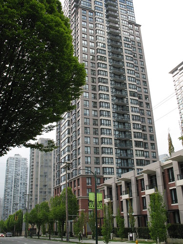
Subscribe to:
Posts (Atom)