With Weather Like This Who Needs New Stormwater Infrastructure?

by Krystal Meiners, VIA Architecture
Unfortunately, we do. Despite the last two weeks of glorious clear skies and mild weather, I will venture to say that rain is still typically a way of life here in Seattle and the Puget Sound region. And unfortunately, with all of the rain, comes a heap of problems that trickle down our streets and hillsides and waterways, heading straight for our Sound and the Pacific beyond.

With nearly 4,600 manmade outfalls (not including 93 combined sewer overflow outfalls), emptying directly into our waterways, we may as well be funneling motor oil into the mouths of our precious salmon. Too dramatic?

Well, beyond my bleeding heart, new stormwater infrastructure just makes sense and is perhaps a bit overdue, for several reasons.

Over the last century, stormwater has increasingly carried more and more pollutants such as motor oil, construction sediments, and animal waste over roadways, across parking lots, through lawns treated with pesticides and any amount of other down and dirty routes towards the Sound causing:
  • A dive in water quality
  • Loss of habitat
  • Polluted public spaces such as beaches and waterfronts
  • Rising deaths in wildlife (shellfish, salmon, sole, etc.)
  • Rising sickness in wildlife
  • Soil erosion
  • Flooding and property damage

Several organizations, such as People for Puget Sound, the Puget Sound Partnership, the University of Washington, Environment Canada, several Washington state tribes, and The Washington Environmental Council are all working at various levels in policy and action towards improving our infrastructure and implementing sustainable stormwater strategies like LID.

The key to improving the quality of stormwater and the management of dangerous sewer overflow lie in an abundance of civil works projects. New legislation, such as the Working for Clean Water bill (HB 3181/SB 6851) is proposing just that and is intended to fund projects all over the region to help people get back to work and to improve the quality of our waterways at the same time.

Investing in sustainable storm water infrastructure and low impact development now will improve the quality of our water, our wildlife habitats and the appearance of our cities and will help move Washington forward in our vision for a sustainable future.

Image Credit:
Image 1: Polluted stormwater warning sign at Manchester Beach on Puget Sound (Photo by Ricardo Vargas)

Can Seattle Walk the Talk?

by Kate Howe, Urban Planner for VIA Architecture

Much of our combined city planning energy has been focused on traffic; how to plan for it, how to make space for it, and how to keep people from getting in its way. However, the methodologies championed by Danish urban expert Jan Gehl and his team at Gehl Architects are finally giving neighborhoods and community advocates the facts they need to compete in a world dominated by traffic demand models, population forecasting, and abstract regulations that do not value public realm.

In this way, a paradigm shift is taking place around the world, bringing with it a new fact-based level of empiricism to our sometimes too subjective conversations about sustainable urbanism. Gehl promotes a data driven view for improvement-based on watching and quantifying what people do in public space, how often they do it, and where. It seems simple, because it is.

We too can become experts at understanding how life, mobility, and people can be invited back to the city.

The tricky part is collecting and paying attention to this data. As of today, Copenhagen is the ONLY city in the world with a Department of Public Life. This is not a Traffic Department, or a Building Department, but a city agency that is consistently engaged with the everyday users of a city, its pedestrians, its residents and its commuters.

Over time, a close relationship between the progressive City Engineer and City Architect in Copenhagen and Jan Gehl’s lab at the Royal Danish Academy of Fine Arts helped to validate the small changes happening on the ground – taking back a parking space here, improving a pedestrian street there. Now we can quantify how many more people are living and using Copenhagen’s streets and how it is that they are using them. Perhaps most exciting for me, during the forty years of incremental change for the better, a priority on having a rich public life survived through many administrations, was depoliticized, and ultimately began to feel more like a basic civic right.

For our struggles in Seattle, Gehl Architect’s Founding Partner, Helle Soholt presented last night a first glimpse into our own 
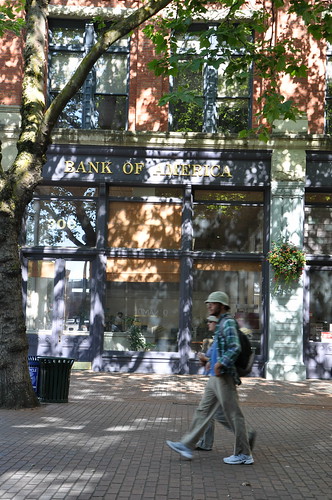
Public Life Study (due out in full in March). It confirms what many of us who work downtown already know:
  • that the office core is lifeless throughout the day
  • that one has to walk to the edges, or the Pike Place market to find a nice place to sit and have lunch
  • that you don’t linger unless you are waiting for a bus.

They know this because they had 43 graduate students at the University of Washington standing at street corners through out the downtown counting people. They did this in all seasons, days, nights and weekends. Observing and marking down what people are doing; i.e. are they sitting, standing, for how long?, walking, talking, shopping? The Study will also show how these activities rank up versus other cities of our size such as Melbourne and Sydney Australia. (Hint, not so good)


While I could go on to discuss Gehl’s projects and this Study at length, you can instead watch nearly the whole presentation here. (You can also watch the introduction to the presentation by Todd Vogel, Sally Clark and Mayor McGinn by clicking here.)

But overall, my conclusion is simply that the time has arrived! I hope that we can learn to pay attention to the map Gehl Architects has begun to provide. As Helle noted:
  • "We need to give something to the city in order to get something from the city."
  • "Every person in the city is a part of the city’s culture."
  • "Most importantly the function of public space is that it is democratic, open and accessible to all.”
 In sum, their five recommendations for Seattle:

1. Connect between Pike Place Market, the Waterfront and Westlake Center
These are the areas with the most active life now, how can we pull some of the activity from Pike Place towards the rest of our downtown? What can we do about the parking lots and junky urban design here? What are we saying at eye level invitations to the waterfront?


2. Complete the Bicycle Network
While pictures of Copenhagen’s famous cycle tracks are sure to make any cyclist drool, the recent changes in New York City are a great US precedent. Give us a safe – separated cycle track downtown so that even grannies feel like taking their bikes out. Please, and thank you.

 Photo by citywalker

3. Prioritize a First Avenue Pilot Project
Gehl Architect’s study shows First Avenue as the primary connector between languishing Pioneer Square and the Pike Place Market, by far our most vital walking environment downtown. They suggest we treat it that way. While retail owners may be nervous about losing traffic volumes and parking spaces, more hard data continues to show (such as in the recent PLANYC) increased walking traffic can be correlated with more retail sales. And we have a LOT of room for growth on First Avenue if we designed it for better connections and walkability.
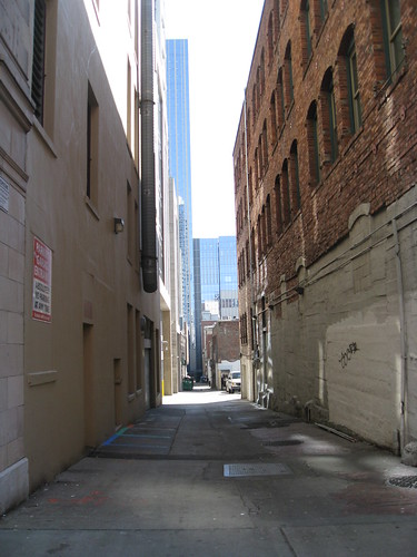
 Photo by citywalker
4. Green our Alleys
Our streets are broad in Seattle, with one way fast moving traffic. Like Melbourne we have an opportunity to green our narrower and intimate alleys, remove the dumpsters and make new smaller scaled streets and places. These can be the places to stay. They also recommend simply greening the east-west connectors with sitting benches and places, street trees to make the incredible topography less challenging.


5. Make new facades where none exist
Hallelujah. Helle mentioned, first that we have something like 75,000 parking spaces in the downtown; we can sacrifice a few at the street level to make new storefronts and facades. What is the city doing to make this happen?

A look at Vancouver's high capacity transit system

The New Partners For Smart Growth National Conference was held in Seattle in Early February. VIA's Matt Roewe, Director of Mixed Use and Major Projects, was a featured speaker and panelist in a special session on best practices in transit oriented development.

This panel was Moderated by Vancouver's Gordon Price, Author of Pricetags.ca and professor at SFU. Other panelist included David Alumbaugh, Director of Citywide Planning in San Francisco and Lyle Bicknell, Neighborhood Planning Manager for the City of Seattle.

Matt's presentation featured a primer on Vancouver's high capacity transit system (Skytrain and the Canada Line). He also featured five station areas of various ages, each with it own set of transit integration variables and development determinants. Tremendous lessons can be learned from 25 years of successful transit planning and station area development in Vancouver.

Take a look at Matt's presentation here.

More information on the New Partners for Smart Growth Conference can also be found at:
http://www.newpartners.org/index.html

Monday News Roundup

Working for Clean Water 
WCW is about creating jobs, rebuilding our local economy, and cleaning up polluted waterways like Puget Sound and the Spokane River. Each year millions of gallons of petroleum pollute our water through storm runoff, a serious threat to our health and environment. Working for Clean Water will fund shovel-ready, local projects all over the state to stop this contamination. Now is the time to put Washington back to work by building storm water infrastructure that we’ll be proud of for generations. 

The Foodprint Project
Thinking about how zoning, policy, and economics shape our urban food systems? NYC is hosting an international conversation.

Blind architects have a real feel for the site lines  (LA Times)
Blind architecture in LA. Unable to see their designs or those produced by others, blind architects get more in touch with their other senses.

BC #1 in economic growth  (Vancouver Sun)
B.C. will post growth of 3.7 per cent over the year, while renewed American auto demand will help Ontario surpass the national average for the first time in nearly a decade with growth of 3.5 per cent, the board said in its Provincial Outlook — Winter 2010, released Monday.

Record Number Taking Transit in Vancouver (Vancouver Sun)
More than 1.6 million people a day used buses, SkyTrain, the SeaBus and the West Coast Express, according to TransLink.

Bloom box: An energy breakthrough? (CNET)
What happens when suburbia pulls itself off the grid... and every home features a new massive accessory building? 
 
Proposed zoning code update draws business objections (Anchorage Daily News)

"Landscaping softens a building whether it's good or bad," and it's what most people see when they drive by, Brown says. Isn't that the whole problem? The driving-by?
 
A good look at Vancouver's Southeast False Creek neighborhood and the Olympic Village, which just achieved LEED Platinum.

In many parts of the world, women rely on public transportation more than men. And women are more fearful than men being out in public spaces. This study looks at women’s particular needs as transit riders, especially in respect to safety and security. What are they afraid of? What are the issues they are facing? But the other part of the study has to do with how these needs are being met, or not met. And then finally, are there any innovative solutions?
 
I love this city, but when I see this, it makes my heart pound. This photo of a spontaneous street hockey matchup on Granville street on Tuesday night is another example of our city at its best. Apparently, five guys from Minnesota challenged Canadians to a game, only to be defeated.

Seattle's First Blogger/Twitter/Seattle-ites Meet Up

We hosted our first meet up in Vancouver almost a month ago, and were really excited about our Seattle meetup/tweetup/blogger meetup, which happened last night at the Pike Brewery Co, which was the perfect venue.

Just like in Vancouver, the goal of the meetup was not only to learn more about some of our local bloggers, but also to continue the dialogue we started back in June when we produced the Great Urban Debate (Seattle vs. Vancouver).

Instead of comparing Seattle vs Vancouver, however, we hope to facilitate conversation between cities in the Pacific Northwest, including Portland. We believe this will enable us to discuss important issues while getting feedback from those that are local, as well as our urban city counterparts.

A big thank you goes out our social media consultants at Banyan Branch for partnering with us and helping organize the event, and to Pike Brewing Co for hosting the event. We had almost 100 people come through the meet up (some just wondering what a "tweet up" was...) and had a great time meeting some incredible Seattle-ites.

Thanks again to all who attended, and congratulations to @mattgoyer who won the drawing for the $30 Visa gift card.


The Running of the Flame

by Naomi Buell, VIA Architecture Vancouver


The running of the flame has a bit of a controversial past, having been introduced at the Berlin Olympics during the Nazi regime. Today, it represents hope, sportsmanship, and the interconnectedness of nations. The flame is ignited in Olympia and crosses through many continents to arrive at the central stadium of the Olympic host nation. The flame has had an adventurous and interesting history and has traveled through many mediums including boats, canoes, deep sea divers, camels and was even transformed into a radio signal in 1976.

Last Friday, our Vancouver office was fortunate to see this wonder as it made its way to GM place in time for the opening ceremonies.  It would seem that every office had the same idea as the excited crowd covered the streets. Some people even stood on dumpsters, hung out of windows and off balconies and watched from their roofs. Some VIA-ites were lucky enough to see it at multiple locations as it made its way all over Vancouver.

As the flame approached, the crowd narrowed, causing the running of the flame to become more of a walking of the flame in order to make it through the many obstructions (mainly people) in the way. Once the torch bearer had passed in front, all that could be seen was a small flame above the heads of the proud people following behind.

 This is it Vancouver, the Olympics are finally here and as incoming COC president Marcel Aubut said, "We will be the best hosts on the planet, because we are hosting the planet -- but on one thing there will be no compromise. These Games are ours."

Nothing like a little friendly competition to kick off the games.

Pencils or Breadloaves in Seattle's South Lake Union?

Unlike Pioneer Square, who resists height increases due to the historic nature of the neighborhood, a recent Seattle Times article looks at South Lake Union and its potential for taller buildings with certain bulk controls and tower spacing. Current residents are concerned, however, that they'll be "walled in" and others worry that they'll lose views of the Space Needle, the lake, and even the sun.

As South Lake Union's biggest landowner, Vulcan is entrenched the process and has been working with residents and neighborhood activists to hear their concerns. Matt Roewe is VIA's Director of Mixed Use and Major Projects, and is also a member of the Planning Commission. As a resident of Queen Anne, he has been on many committees about South Lake Union's future, and even sits on the neighborhood's design-review board.
"Roewe agrees with Vulcan and the city that the current zoning in South Lake Union has led to 'breadboxes' — low-level buildings that fill entire blocks. Instead, they propose 'pencils' — tall skinny towers that leave room around the bottom for views and public spaces.

Part of the discussion, no doubt, will include exchanging the right to build taller for an agreement to add green space or other community amenities."
Among the committees that have been working on South Lake Union, Matt participates in the following: Two Way Mercer Stakeholder group, South Lake Union framework charette, South Lake Union height & density study committee, and the Uptown South Lake Union visioning charette stakeholder group.

Back in 2008/2009, Matt partnered with the Great City Initiative in their "Leadership for Great Neighborhoods" campaign that aims to guide growth in Seattle's emerging urban centers.

To see the combined Leadership for Great Neighborhoods presentation, which includes Matt's "pencil and breadloaves" presentation, click here.

VIA Architecture & Banyan Branch Present a Tweetup

Join us for our first Seattle Meet-up!

What:
Stop by for some free food and network with others interested in architecture, urban planning, and transportation. Come meet local neighborhood bloggers (like the New Pioneer Square and Citywalker) and other great Seattle tweeps (like @hotel_max, @alexgarcia and @jessestrada).

When:
Wednesday, Feb 17
5:30pm - 7:30pm

Where:
Pike Brewing Co.
1415 1st Ave.
Seattle, WA
Map

Who:
Anyone and Everyone!
Meet up hosted by the VIA and Banyan Branch

Are you on Twitter? RSVP here: http://twtvite.com/t0ququ/

Monday News Roundup

Who takes public transit? (Granville Magazine)
Did you know that 61% of Vancouver transit riders do so by choice, not necessity? Check out this and other statistics, including age, gender, employment and household income.

And while you're checking that out, check out this study by the Mineta Transportation Institute: How to Ease Women’s Fear of Transportation Environments


Portland to get 250ft Vertical Garden (Inhabitat)
Our neighbors to the south always seem to be one or two steps ahead of us.

The rise of vertical farms (Scientific American)
A nice post about vertical farming

Some lettuce grows in Manhattan (Archidose)
A look at the forms that several hypothetical vertical farm proposals are taking

Vectorial Elevation
Be an artist - light up Vancouver's skies YOUR way! Vectorial Elevation is an interactive artwork that allows participants to transform the sky over Vancouver, Canada. 

As suburbs reach limit, people are moving back to the cities (Seattle PI)
Desolate inner cities, surrounded by burgeoning suburban growth, were a feature of late 20th Century America. Donovan sees a reversal in the trend. "We've reached the limits of suburban development: People are beginning to vote with their feet and come back to the central cities," he said.
This post from GOOD looks at how a street can become a bicycle corridor.

_________________________________________________
_________________________________________________

If you're on twitter, follow us at @viaarchitecture

We're having our first Seattle tweetup! Join us and @BanyanBranch @pikebrewing next Wednesday, 2/17 at 5:30pm - RSVP here: http://twtvite.com/t0ququ/

Commuter Parking at Seattle's Light Rail Stations

by Matt Roewe, AIA, LEED AP
VIA's Director of Mixed use and Major Projects

There has been a lot of discussion and debate lately regarding Mayor McGinn’s proposal to suspend the enforcement of a Seattle ordinance that prevents all-day paid parking near light-rail stations. Citizens are looking at the underutilized areas at these stations and now pressuring the mayor to change this policy. I have been discussing this in house at VIA with our planning and urban design team, as well as with my fellow planning commissioners. The Seattle Planning Commission is writing a letter to City Council and the Mayor with our thoughts on this. Look for that in the next week. Meanwhile, my personal thoughts are summarized here.

Not allowing park and rides in urban station areas is a generally a good policy 
Parking, especially when it is free and used all day by commuters, tends to become an issue that encourages driving as a habit, and works against good place-making and sustainable living strategies. However, some short term flexibility is worth considering while we dig our way out of this down economy.

The new light rail system needs more ridership support
I have heard that dally train boardings are underperforming expectations. So, until more capacity/density can be established within walking distance (rezoned and built), interim strategies should be explored. Significant responsive development may take 10 to 25 years to come to fruition in some station area locations. Even some station areas with unrealized commercial development on Vancouver’s high capacity transit system (Skytrain) are still well behind the ridership targets after 25 years. Meanwhile, existing lots here in Seattle sit underutilized during the work day.

The mayor’s proposal targets only existing parking lots, so the notion of establishing parking as a new single use is off the table
The benefit is that nobody will be tearing down a building to make a parking lot or stand-alone parking structure. The key is to incrementally take away the parking lots that exist now by establishing a penalty or tax for using them for all day commuter parking. Initially, there would be a small tax per stall within the station area, but it could be ratcheted up every year to make that use less viable. I equate this to the Darwin-like evolutionary process of getting people out of their cars and into a more urbanized, walkable lifestyle. It won’t happen overnight. Some areas will happen sooner than others, so a one size policy should not be applied at every station area.

I’ll also point out that the City and Sound Transit need to continue to work closely with Metro to improve bus integration service and frequency east/west to the alignment and in loops around the greater station area neighborhoods. Many high capacity transit station areas in other cities have 40 to 50% or more of the LRT ridership start or end with a connecting bus. This effectively will reduce the need for parking in the station area and give the whole neighborhood more reasons to evolve into a vibrant, walkable, better connected and less car dependent place.

Another critical issue is significant transit supportive rezoning has not yet taken place
Up-zones bring value to properties and bring more reason to owners to sell or consolidate smaller properties for higher and better uses than one story strip malls or surface parking. Of course this needs to be done sensitively to preserve historic structures and neighborhood character and keep local businesses and affordable housing in the equation (amenity based incentive zoning, which is a huge topic we won’t address here). Up-zones would do more to eventually make surface parking economically undesirable. New development should also be encouraged to consider shared parking strategies with transit commuters for approximately 25 to 30% of their structured parking that may otherwise sit empty during the work day.

Parking is a resource and an asset that can be utilized and manipulated under the right circumstance to get the results desired. Every neighborhood/station area plan needs a well conceived parking strategy that is incremental and flexible. As Graham McGarva (Principal at VIA) often says: “…inside every car is at least one pedestrian that shops and supports the station area and the transit system.” Station area retailers (in this context) need the short term street parking to support their businesses, but all day commuter parking may not be all that helpful for them. Incrementally, a neighborhood can eventually wean itself from their dependency on cars. Until a critical mass of residents and workers exists and better bus/bike cross integration is established, a car dependant area will need to transition slowly to reduce the parking ratios and take away stalls. It took 20 years to remove parking lots in downtown Copenhagen. It never would have been accomplished if they tried to do it all at once.

I suggest that current parking uses be allowed to provide all day commuter parking for one year as an accessory use with a modest tax. After that, start imposing a greater tax that gets more aggressive every year. Also allow the possibility to re-visit the tax increase each year at each station area in response to economic and development realities. Meanwhile, we need to work on the up-zones, do more planning and bus integration.

I hope the banking system frees up capital and loosens lending restrictions soon so that this parking use discussion will be a brief footnote in the transformation of Seattle’s new station areas. Then we can all get back to sensitively infilling and appropriately redeveloping these fine grain communities into livable, walkable places. Meanwhile, let’s support the systems ridership and not underutilize an existing parking resource.

Image Credit: Rainier Valley Post

Monday News Roundup

Techno Jeep (YouTube)
So once we get everyone out of their cars and on to a bus/train/their feet, what do we do with all those cars? We make music!

David Miller's Legacy (CBC)
Here’s an interesting interview with outgoing Toronto Mayor David Miller about his legacy with respect to his transportation initiatives.

Trainspotter’s guide to the future of the world (NY Times)
A comparison of the new ultra-high-speed-train service in China, transportation in Europe and Japan, and why America is so far behind.

SF plans ambitious transit center (NY Times)
San Francisco has an ambitious plan for a new urban neighborhood with a $4.2 billion public transit hub as the centerpiece of the project.

Three Cool Concepts for Urban Biking: (EcoGeek)
The Copenhagen Wheel, YikeBike Mini-farthing, and underground bike storage.

New Commuter Shopping Centre (Global TC)
Plans for Canada's new commuter shopping centre unveiled in New Westminster.
About Active Living Research  (Active Living Research)
The latest in best practice and research where public health meets urban design.

Obama to Give High Speed Rail the Go-Ahead (Daily Kos)
Advocates are expecting a $2.5-$2.6 billion grant for the country’s first 150+ mph passenger train in Florida. "Not only are these the kind of projects that are long overdue in America, they also offer an opportunity for exactly the kind of messaging on government stimulus projects that the White House should be engaging in every week."

A Bike-Ped State of the Union: 9.6% of Trips, 1.2% of Federal Funding (Streesblog Capitol Hill)
"Overall, the report found that biking and walking account for 9.6 percent of all U.S. trips (0.9 percent of that share from biking, 8.7 percent from walking) but just 1.2 percent of federal transport spending."